Amsterdam Netherlands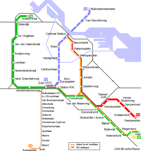
Amsterdam Netherlands
The metro system in Amsterdam is a combination of full metro and rapid trams (sneltram) running mainly on the surface. Only 3 5 km in the city centre between Centraal Station and Amstel are underground. Lines 51 53 and 54 share tracks between Centraal Station and Spaklerweg. Large parts of the metro network run parallel to NS mainline rail lines and cross-platform interchange is provided at Amstel Duivendrecht (north-south) and Bijlmer whereas Sloterdijk Lelylaan Zuid RAI and Diemen Zuid railway stations lie adjacent to the corresponding metro stations.


In 1977 the full metro lines 53 (Gaasperplaslijn) and 54 (Geinlijn) opened between Weesperplein and Gaasperplas and Weesperplein and Holendrecht. Three years later in 1980 both lines reached the Centraal Station. The 54 branch was extended to Gein in 1982. Only 4-car trains are used on these two lines. Both lines operate every 12 minutes which together with line 51 means a 4-minute headway along the common stretch from Centraal Station to Spaklerweg. Both lines will undergo a massive renovation: the concrete stations will be replaced with new stations with a lot of glass. The name of the project is "metromorfose".


Line 51 (Amstelveenlijn) was opened as a rapid tram (sneltram) in 1990 it shares tracks with the metro line from Centraal Station to Spaklerweg then part of the new ring line 50 to Zuid/WTC and finally runs south to Amstelveen and Middelhoven (Poortwachter). Light rail vehicles on this line are narrower than the metro cars therefore they have a platform fixed to the doors to bridge the gap at metro platforms this platform is folded down at Zuid/WTC where also the pantograph is lifted up for overhead power supply along the street level section south to Poortwachter. The entire southern light rail section is on reserved track between car lanes mostly segregated by hedges but many streets cross the line along its route. As far as Oranjebaan these tracks are also used by standard tram line 5 (to Binnenhof) therefore stops have two level platforms (like many German Stadtbahn networks). Some stops have a central platform. Destination shown on panels is not Poortwachter the name of the last stop but A'veen Middelhoven the names of the neighbourhoods served. Work on a 2 km extension has started with three new stations Spinnerij "Sacharovlaan" and "Burgemeester Wiegelweg". It is scheduled to be completed by the end of 2002.


Line 50 (Ringlijn) opened June 1 1997 and is fully on the surface mainly on a viaduct. Coming from the north (Isolatorweg) it joins line 51 at Zuid/WTC and then turns south to Gein along line 54. Typically Dutch trains on this line are equipped with a special bike rack. The side of the platform is announced by an arrow. Apart from Sloterdijk and Lelylaan all stations along the ring line look quite the same (see Jan van Galenstraat picture above).


After long discussions finally construction work for the north-south line should have started in 1997 although now 2000 is a more likely date. The 9.8 km long line will begin at Buikslotermeerplein in the north of Amsterdam meet line 51-54 at Centraal Station and cross the city centre to Amsterdam's South Railway Station (Zuid/WTC). From Buikslotermeerplein to the next stop at Van Hasseltweg it will run on the surface from there it will be underground in a 4 km long and 20-30 m deep bored tunnel with underground stations at Centraal Station Rokin Vijzelgracht Ceintuurbaan and RAI/Europaplein before leaving the tunnel and entering Zuid Station. The line should be ready for operation in 2008.
All metro and sneltram lines operate between 6:00 and 0:30 at a basic 12-minute interval which is increased through bundled routes or by extra peak-hour trains. Amsterdam is part of the all-Netherlands zonal system for which strip-cards are available:
2 strips (1 zone minimum) = NLG 3.00 3 strips (= 1 hour network ticket) = 4.50 8 strips (= day ticket) = 12.00
For unlimited travel in Amsterdam day tickets at NLG 11 are the best deal (2 days = 17.00 3 days 22.00 etc.).
Season tickets are available according to "stars" i.e. one or more zones plus the adjacent ones.

(1) a north-south line branching out both at its northern and its southern end;
(2) a southeast-southwest line crossing (1) at the Central Station;
(3) an east-west line also functioning as a ring line around the city centre crossing (1) at the Weteringcircuit and (2) at Weesperplein and at a station near Leidseplein
(4) a ring line around the pre-war built up area of the city (only half a circle south of the IJ)
Although the north-south line coincides with the main transport axis of the city (and for that reason could be considered as the most important and most urgently needed line) it was decided to start with the construction of the southeastern part of (2) for the following reasons: - it had the shortest underground section (only 3 km); so construction was relatively cheap and moreover could be used as a test case for further construction; - it connected the city centre with a newly planned area (Bijlmermeer) an urban area the layout of which was based on a thorough separation of car and other traffic (so the metro was an intrinsic element of the urban plan); - within the city centre the line crossed a rather derelict area (the former Jewish quarter of Amsterdam) the necessary demolition of which was considered not to be very problematic. Construction started in the second half of the sixties. The start coincided with the onset of the 'protest and revolt movement'. The metro itself (underground public transport means the final hegemony of the car on the street level) and the demolition of a characteristic area combined with the reduction of the cheap housing stock (very much in favour with squatters-avant-la-lettre) became an important focus of that movement. In the end the image of the metro was very negative not only among the members of the protest generation but among a majority of the Amsterdam population - with the exception of the alderman responsible for transport planning .... Partly due to obstruction but mainly due to a wrong calculation of the costs the construction of the southeastern part of the southeast-southwest line (to which the part of the east-west line serving the eastern areas of the Bijlmermeer was added as a temporary branche line) proved to exceed the budget in such a way that shortly before the opening in 1977 the national government which in the meantime had taken over the final responsibility for urban public transport investments decided to annul the so-called metro decree. No other metro line than the one already built (now simply referred to as the east line) would ever run underneath the surface of Amsterdam.
APTI - Amsterdam Public Transport Information (private page) map list
Noord-Zuid-Lijn Project or Noord-Zuid Lijn (same)
Noord-Zuid-Lijn (new site)
Metro & Sneltram Press Archive (in Dutch)
Roy West's Sounds & Pictures of Amsterdam Transport
Dave Pirmann's Page has hundreds of photographs on Amsterdam Transport incl. Metro
metroPlanet - more Amsterdam metro pictures
Map by M.Koch
Kind of official map imitation
Han Schomakers' page which explains colour-coding on Amsterdam metro and tram cars
Thanks to Philip Spangenberg and Wieger Vanderslikke!
© This is a metroPlanet Europe page designed by Robert Schwandl.
If
- you know of any other interesting pages that should be linked from this page
- you have any updated information on this city's metro system
- you want to suggest anything on this page
please send me an e-mail!

